Wednesday, April 29, 2009

Salar de Uyuni, Bolivia

From San Pedro de Atacama we were ready to head into Bolivia. In order to make it to the closest town in Bolivia, Uyuni, we needed to cross desert, geysers, hot springs, lakes, and salt flats. So, we made a 3 day 4x4 Land Cruiser tour out of it- a definite highlight of the trip! There were 11 people in our group so we needed two vehicles. We lucked out and had a really fun group made up of us, 2 Swiss girls, 2 (hilarious) Israli guys, 2 Portugese girls, an English girl, a Brazilian girl, and an American girl. Our guides were proficient in cooking, site info where we stopped, and automobile repair! Again, we had so many pictures to choose from. Here are the highlights from the tour:

DAY 1

We ate breakfast at the Chili-Bolivia border sheltered(sort of) from the cool winds of the altiplano. This was the the closest we got to the Licancabur Volcano(5930 m). The border crossing consisted of one building in the middle of no-where with no real roads leading to or from it. There was one border guard there that could be bribed if you did not have the necessary documentation. Below is the Bolivian border building along with a glimpse of the Toyota Land Cruiser that was our transprt for the journey to Uyuni.

Laguna Verde was our first stop after crossing the border into Bolivia. This high-elevation lagoon is suurounded by volcanoes- most of which are inactive.


Our second stop was to the geysers that sit at approximately 4950 m. These ones were different from the ones we saw outside San Pedro de Atacama. They smelled of sulphur and the liguid was grey but just boiled, instead of shooted up like the other ones did. These ones were also quite big, like craters in the earth.


Day 2

After spending the night huddled in our long-johns under several layers of blankets we loaded up the 4x4´s and headed out for another exciting day. Below is our ¨refugio¨(hostal) and the guides backing our stuff on the roof racks.


First stop on day 2 was to the nearby Laguna Colarado where the flamigoes live. We didn´t expect to see this bird here in the windy altiplano, but there are three types who live in the area.

During the trip we saw lots of llamas and alpacas strolling along. They are pretty tame so we could get close. These ones have pink ribbons tied to their ears to identify them.

We also stopped at the near-by Termas de Polques hot springs for a quick and relaxing dip at 4200 m.
Our last stop of the day before heading the next hostal was to the Arbolde de Piedra, or rock tree. We were just cruising (OK, bumping) along the desert roads (OK, tracks) when we came across a collection of rocks jutting out in the middle of nowhere. This one is famous because it looks like a tree (kinda).

Day 3
On our 3rd and final day crossing into Bolivia we arrived at the Salar de Uyuni - disputedly the world´s largest salt flat covering approximately 12,000 sq. kms at approximatly 3653 m elevation. The salt from the flats is harvested and processed into table salt, but more importantly the landscape lends itself to taking fun photographs.


Sitting in the middle of the Salt Lake is the peculiar and amazing Isla de los Pescadores or Incahuasi (meaning Fish Island for its shape or Inca´s House). The island has an amazing stand of giant and ancient cactus, some of which have been aged at more than 1200yrs. Archeologists also discovered signs that the inca once used this mysterious island.

The only mishaps we had on the trip were a couple of flat tires, running out of gas, and the other trucks wheel and tire came off at about 80 km an hour off-roading. We were assured by our guides that this trip was smooth compared to most. Our 4x4 adventure ended in the small town of Uyuni but our adventures in Bolivia have only just begun.

Bolivia fun fact: Bolivia is the hemisphere´s highest, most isolated and rugged nation. In guidebooks, the country is described as one of the Earth´s coldest, warmest, windiest and steamiest places. It boasts among the driest, saltiest and swampiest natural landscapes in the world.

Thursday, April 23, 2009

Into Thin Air- Tha Atacama Desert

San Pedro de Atacama is the main jumping-off point to expore the Atacama desert in North Eastern Chile. From La Serena we travelled 18 hours (with 1 bus change). The small village of San Pedro de Atacama is also at at Altitude of 2500 metres. We could feel the air change throughout the bus ride(which went up over 3500 metres) and when we disembarked our ankles were the size of oranges- indeed, we had cankles!! The Atacama desert is surrounded by a mountain range on all sides made up of both active and in-active volcanoes.

Day 1:
On our first full day we decided to take a tour to The Del Tiato Geysers. The geysers are most visible in the morning, so we boarded a small van at 4:30AM and headed to the sight.
It took a couple of hours by dirt road to reach the geysers, and by 6:30AM it had warmed up to -13 degrees celcius. The geysers are located at approximately 4320 metres elevation above sea level. ( FYI - By lunch-time it had warmed up to 28 degrees).

There were thermal pools at the geyser site which was a good way to warm up and relax.

Our tour guide to the geysers that day was amazing - he didn´t stop talking for 8 hours straight, switching back and forth between spanish and english seamlessly. In addition to seeing the geysers, we also had lots of opportunities to view native wildlife. Vicuna´s (close relative to the llama) were feeding on grasses at the higher altitudes. Hidden amongst the rocks in several locations were Vizcacha, which appear to be a cross between a squirrel and a rabbit. They are about the size of a large squirrel and look like a rabbit with a squrrels tail. We tried on several occasions to get photos but they are both quick and well-camoflaged and evaded us every time.

Day 2:

We rented bicycles and sand-boards and headed out for the day to give sand-boarding a try.

The landscape was dry, moon-like, and breath-taking(literally)!
When we arrived at the site there were some other trekkers and locals there also giving sandboarding a try.

Sand-boarding is not as easy as you might think. We were using home-made wooden boards that needed to be waxed each time. The wax would only last for about five metres at which point, if you where not leaning back, you would be propelled forward over the board and down the hill.
You may not be able to see in this pictures but our rental bikes were TREK bicycles. They are the best bikes we have rented thus far on the trip and handled off-road very well!!! See the fun-fact for more details on TREK bicycles.
We ditched the sandboards at lunch time and headed the opposite way out of town to and area known as devil´s caynon. Devil´s caynon provided us with a sweet single track for mountain-biking.
The trail crossed streams and at times even went into the hillside.

Day 3:
On our third day we joined another small tour and headed out in the atacama desert for some fun. Our first stop Laguna Cejas, a small salt lake for a swim. The lake was approximately 85% saline, which meant that we could float effortlessly in it. You could not sink to the bottom if you tried!
After the salt lake, we headed back out in the desert for a couple of hours until we came upon a couple of large potholes filled with water. There are a number of rumours about the depth of the potholes. Some guides claim it is more than 800 metres deep, while others suggest it is only 75 metres. In any case, Chris decided it was deep enough to jump in too.
From the potholes we headed to the saltflats to catch the sunset. There was a small skiff of water over the salt-flats which can give the allusion of walking on water in pictures.
Fun Fact: Chris´uncles own bicycle stores in Toronto and Barrie. If you are shopping for a bicycle or just looking for a good website with useful informatation check out: http://trektoronto.ca/

Tuesday, April 21, 2009

La Serena and Vicuna

We left Vallapariso and headed north by bus to La Serena. Founded in 1544, La Serena is located on the pacific coast and is Chile´s second oldest city. Many of the buildings in La Serena still have much of there colonial charm. We stayed in the home of a sweet little chilean woman named Iris. In La Serena, we were hoping to be able to relax on the beach and soak up some sun. Much to our dissappointment, it was too cold to even think about shedding layers of clothing that we have been wearing ever since Ushuia. We went for a walk on the beach anyways followed, as usual, by a pack of stray dogs.

From La Serena we took a short bus ride inland to the village of Vicuna. Along the road we could see acres and acres of grape, avacado, papaya and plantantions along the valley floors.
Uphill from the valleys, the landscape could be described as desert complete with cactus and tumble-weeds.
The remote inland location helps make the hills around Vicuna perfect for observing the stars. As a result, several international observatories have been established close to Vicuna. We booked a tour and talk at Observatorio Mamalluca. Both the stars and our tour guide were amazing that night, and we can now identify several constelations in the southern hemisphere with confidence.

From Vicuna, we headed back to La Serena to catch a bus north to San Pedro De Atacama.

Chile Fun Fact: The most popular junk/fast food in Chile is a hot dog completo. A hot dog completo is a footlong slider with guacamole and somtimes tomatoe and mayo on it. You can get completo´s everywhere!

Colourful hills of Valparaiso

From Santiago, the bus ride to Vina del Mar is only 2 hours west. Vina del Mar (Garden City) is a touristy beach town that is crowded in the high season with beach lovers and vacationing people from Santiago. It was a chilly fall day when we arrived so after getting Jana and Igma settled with their friends we bussed over to nearby Valparaiso to find a place to stay.

Valparaiso is a Unesco World Heritage site and is considered the cultural capital of Chile. It is Chile's first port and from the shore the downtown lies at the bottom of several Cerros (hills) on which colourful houses are precarioulsy stacked. The hills are connected to each other and to the downtown via step footpaths and the city's famous elevators, built between 1883 and 1916. We spent the day exploring a bit of the city with Jana and Igma, ascending the hills in the elevators and walking down through the narrow, steep streets.


We said goodbye to Jana and Igma after having dinner with them at the home of their friends in Vina del Mar. We spent one more day in Valparaiso wondering up and down and around the Cerros and in a downtown park. On our walk we came accross the Museo Cielo Abierto, an open air museum. It was a few streets at the top of a Cerro that showcased art on some of the walls of buildings.


It was cool but sunny so good weather for taking in this amazing city. Time to head North, and the next day we boarded a bus for La Serena, a 6 hour ride.

Wednesday, April 15, 2009

Santiago de Chile

To get to Santiago, Chile we crossed the Andes from Mendoza, Argentina. The border is super strict there as they absolutely do not want you to bring fruit, meat, or cheese into the country. They have sniffer dogs and bag scanners. The border is near the top of the mountain range. From there we could see Aconcagua mountain, the highest peak in South America at 6960m. The road taking us down the mountain was a series of switchbacks. In this photo we are already halfway down!


In Santiago we met up with Mel Reid, from Huntsville, who is living in Santiago with her partner Alvaro. They were just leaving to go on a bike trip to the North of Chile, to the Atacama Desert. We are also making our way there so we might see them again. We had a nice dinner with them (below) at their apartment before they caught their bus.


We went out that night with another friend from Canada who was spending some time in Chile before moving to Montevideo, Uruguay. Jana, is with her Chilean partner Igma. We had dinner together and met up with them the next morning to travel together to the costal towns of Vina del Mar and Valparaiso.

Saturday, April 11, 2009

Mucho vino in Mendoza


A 20 hour bus ride (no big deal after Route 40) north of Bariloche is Mendoza with its´laid back vibe, plazas, cosmopolitain cafés, and wide, leafy avenues. There are lots of trees and fountains adorning the plazas here but Mendoza is a desert town. Irrigation ditches even run beside every main road with fresh water pumping through them.

Mendoza is also synonymous with wine. The areas sourounding the city produce some of the world´s best wines. The climate is dry so they have to irrigate but the consistent weather (warm but not too hot in the day and temperatures not approaching freezing at night) make this area otherwise ideal for growing many varieties of grapes.


We joined in the fun and took a citybus out the the town of Maipu where we rented bicycles had a day-long wine tour. We cycled about 20km in all and headed to the winery the furthest away to start the day. This winery also ended up being our favourite so next time you are out shopping for wines look for the Carinae vineyard (http://www.carinaevinos.com/). They make mostly reds, but have a couple whites and a rosé too. At the Carinae winery the owners are especially passionate about astronomy and Carinae is the name of the owners favourite constellation. Each of his wines are named after a different constellation.


In total, we visited 4 different wineries, 1 olive farm, and 1 chocolate/liqueur/jam maker. At each winery we got a tour and a sampling of 2-4 different wines. We learned how to taste the wine (an exercise involving taking the wine in visually and smelling it before tasting).


Parque General San Martin became a favourite of ours in Mendoza. We walked along the lake where rowers practiced and snoozed in the shade of the rose gardens in this 420 hectare park on a couple of different occasions. One day we rented bikes in the city and rode atound the park and eventually made our way to the Cerro de la Gloria which is also in the park. We tied our bikes at the bottom and walked up for a view of the city and the valley of the Andes. The monument at the top celebrates the liberation og Argentina, Chile, and Peru from the Spaniards.


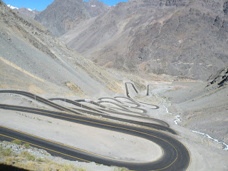
As travel at Easter is pretty crazy in Argentina we stayed put in Mendoza for a few days sipping café and eating helado along the pedestrian street, visiting the park, eating some good ol´Argentine beef and drinking delicious wine before heading across the border to Chile.


Argentine Fun Fact #7:

Besides rat-tails and mullets, also popular in Argentina is having 1 dreadlock at the back that is longer than the rest of the hair. It seems weird to us.

Monday, April 6, 2009

El Bolson ice cream and Bariloche chocolate

Our long journey on Route 40 ended in the town of El Bolson. Technically still in Patagonia, the landscape has changed quite a bit to mountains and lakes. El Bolson in nestled between 2 Andes mountain ranges on the north end of the Patagonia region in the Lakes District of Argentina. This little town has many fruit and hops farms on its outskirts which lay at the bottom of the mountains. The area produces 3/4 of Argentina´s hops, making for some great micro-brews here.


We would have liked to get a hike in during our stay in El Bolson but as it turned out, we had a lot of time to sample the beer as it was raining when we arrived kept on and off throughout our two days there. We wandered around town and did a fair bit of lounging in the cafe´s, eating helado from the best helado shop we have found yet (called ´Jauja´), and reading.


We also visited the Feiria Artesenal. Anyone can set up shop at the market so long as their wares are homemade. We ate a lunch of empanadas and micro-brew beer as well as delicious belgian waffles with fresh raspberries on top.


We continued our journey north of El Bolson with a stop in Bariloche. This medium-sized city of 98,000 sits on the shores of Lago (Lake) Nahuel Huapi in the middle of the National Park of the same name. The soaring peaks of Cerros Catedral, Lopez, Nireco, and Shaihuenque- all over 2000metres high ring the town- and we saw them when the rain stopped and the clouds finally cleared on our last day there! It resembles a swiss town with log buildings and even barrel-toting Saint Bernards in the main square! It is also home to delicious chocolate shops and is Argentina´s chocolate capital. We took it upon ourselves (with Easter approaching and all) to sample a few of them in order to decide which shop had the best chocolate in town. We found it in the chocolate covered mints (like a Peppermint Patty) called ¨mentitas¨.


Argentina Fun Fact #6:

Argentinians love their naps. Most stores close for lunch and siesta from around 1pm-4pm. They then re-open until 9 or 10 at night. If it´s warm out, some people head to the parks and plazas for their mid-day naps.

Friday, April 3, 2009

RTA 40

The quitensential road trip through Patagonia is Route 40.

Route 40 remains largely unpaved as we made our way north along the western border of Argentina; from southern Patagonia to northern Patagonia, from El Chalten to El Bolson. We rarely saw any vegetation higher than our knees in this arid desert-like landscape. Occasionally we saw a hill on the horizon. Like the Praries in Canada it was often the sky that was changing as the bus floated along the gravel roads, swerving slightly with the looseness of the roads. Sometimes we would get a brief break from the gravel with a small section of paved road but those were infrequent and short-lived.

There is not much else to tell in words about sitting on a bus for two days, so we will let the pictures tell the rest of the story:


Argentina Fun Fact #5:

Argentine ice cream is delicious! It´s called ´helado´ and comes in dozens of flavours that they scoop out of large vats with a spatula. Our favourties are limon (lime) and frambuesa (raspberry) in waffle cones or waffle dishes.